Coastline ownership
Why we monitor coastline ownership
The coast is widely perceived as a public open space, which should be accessible to everyone. Public access is highlighted as a matter of national importance in the New Zealand Coastal Policy Statement (NZCPS). Our Regional Policy Statement (RPS) and Regional Coastal Plan (RCP) also emphasise that public access within the Coastal Marine Area (CMA) - along the foreshore and across the water - should not be unduly restricted.
Public access to the coast (and other areas) relies on the provision of public areas such as access strips, walkways, reserves and conservation areas, or agreements with landowners. The presence of public coastal land can therefore be used to evaluate likely levels of public access, and the availability of highly valued coastal space.
Esplanade areas have a number of purposes including recreation, public access and conservation (including water quality and the mitigation of natural hazards). These purposes are outlined in section 229 of the Resource Management Act 1991.
Results - data and trends
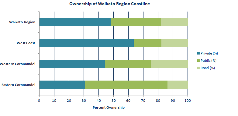
This indicator measures the public and private ownership of the Waikato region’s coastline. The results are presented as privately owned, publicly owned or road edge (assumed public ownership), and have been split into the three main coastal regions – West Coast, West Coromandel and East Coromandel.
Just under half (48 percent) of the entire Waikato region’s coastline is publicly owned. However the percentage of privately and publicly owned land differs greatly between the West Coast, West Coromandel, and East Coromandel.
On the West Coromandel Peninsula:
- just under half (44 percent) of coastline in private ownership
- there is a high percentage (25 percent) of road frontage, due to the steep landscape making inland roads impractical
- residential development is concentrated adjacent to the coast, so there are many coastal margin reserves
- there is relatively good public access from the road and reserves.
On the East Coromandel Peninsula:
- 69 percent of the coastline is in public ownership
- much of the publicly owned coastal land is in the form of a narrow reserve, established during land subdivision.
On the West Coast of the Waikato region:
- a large portion of the coastline is currently in farmland or forestry
- the coastline is much less intensely developed than the Coromandel Peninsula
- 36 percent of the coastline is in public ownership (including roads)
- a relatively small percentage of coastline is fronted by road reflecting the remote and relatively undeveloped nature of the region’s West Coast.
- the largely undeveloped nature of the coast makes public access to many parts difficult or impossible.
| Area | Private (km) |
Public (km) |
Road (km) |
Total (km) |
Private (%) |
Public (%) |
Road (%) |
| Eastern Coromandel | 157 | 283 | 70 | 510 | 31 | 55 | 14 |
| Western Coromandel | 141 | 99 | 80 | 320 | 44 | 31 | 25 |
| West Coast | 432 | 127 | 121 | 680 | 63 | 19 | 18 |
| Waikato region | 730 | 509 | 271 | 1,510 | 48 | 34 | 18 |

Methods - how we monitor
More information
When this indicator is updated
This indicator is updated every 10 years. It was last updated in 2012.


To ask for help or report a problem, contact us
Tell us how we can improve the information on this page. (optional)