"Without the new LiDAR coverage, we wouldn’t have had a very reliable reference of the ground surface pre-slip"
- Renee Schicker, Beca Senior Geospatial Analyst
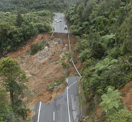
A slip on State Highway 25A following Cyclone Gabrielle. Photo: Beca
Newly released LiDAR elevation datasets for the Waikato region are playing an instrumental role in helping engineers understand what they are dealing with in the aftermath of the major storms in the Coromandel Peninsula earlier this year.
Waikato Regional Council has been working with Toitū Te Whenua LINZ (LINZ) on the five-year National Elevation Programme since 2019 to achieve consistent LiDAR datasets with increased detail across all regions. Ten regions are contributing to the programme, which is now halfway to its goal of acquiring LiDAR data for 80 per cent of the country. Co-Lab is managing hte project for the Waikato region, with the council providing technical expertise.
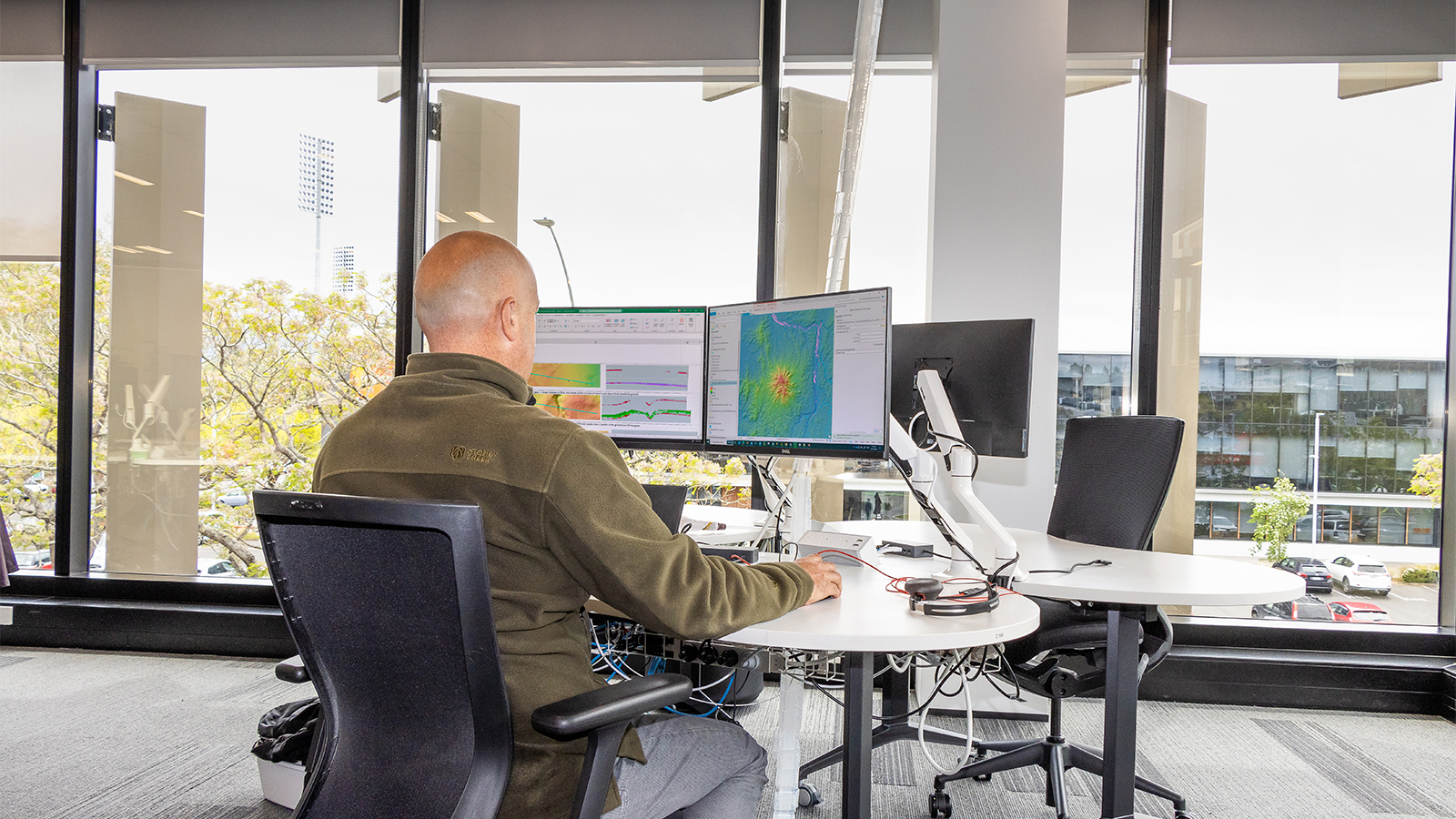
Bryan Clements, the council’s spatial analysis and modelling team leader, says the team has been quality control checking all Waikato datasets, which involves billions of laser points and image pixels, for LINZ to ensure they meet the required standards.
New approved data is already being put to use in the building of a 124-metre, three-span bridge between Kōpū and Hikuaia and understanding landslip risk to properties.
“The detail in these new datasets is a paradigm-shift for councils and all our stakeholders and communities,” says Bryan.
Previously, Waikato Regional Council only had LiDAR datasets for about 30 per cent of the region, mainly of coastal and flood protection areas. Now it has datasets for the entire region.
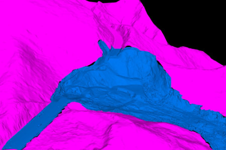
Lidar post slip.
“When our understanding of the land is better, so too is our ability to make better informed decisions around land practices.”
The weather events of the summer, including cyclones Hale and Gabrielle and the Auckland Anniversary storm, culminated in widespread damage across the Coromandel Peninusla, including the collapse of State Highway 25A and multiple landslides affecting roads and properties.
Detailed 3D models produced from LiDAR data, gathered in 2021, gave engineering consulting company Beca an accurate picture of the ground profile of SH25A prior to the slip.
“Without the new LiDAR coverage, we wouldn’t have had a very reliable reference of the ground surface pre-slip,” says Renee Schicker, Beca’s Senior GIS Specialist.
The data also offered valuable insights into slope stability and drainage patterns that may have had a bearing on design options.
Jesse Beetham, Engineering Geologist at Tonkin and Taylor, says having access to high resolution elevation data was invaluable for evaluating landslide risk for properties.
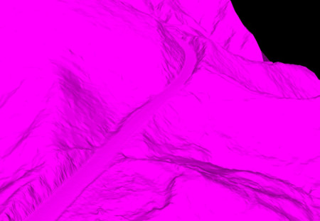
Lidar pre slip.
“We used the new LiDAR dataset during the January and February storm events with our emergency response work in the Coromandel. We were involved with assessing landslides that had occurred across the district and evaluating the risk that these landslides had on properties,” says Jesse.
“In some cases, evidence and observations of a landslide obtained during a site visit pointed towards something larger at play. This is where the new LiDAR dataset became an invaluable resource, as it could be used to generate hillshade models and updated contours for sites of interest.
“It is a huge improvement on the 8m Digital Elevation Model for New Zealand. The high-resolution ground elevation data, with a vertical accuracy of +/- 0.2 metres and a horizontal accuracy of +/- 1.0 metres, allowed us to detect spatial changes in the geomorphology of the land, like historic landslide features. Due to the size of these features, it is not often possible to see them when you are standing on the ground, so this is what makes the new LiDAR dataset an excellent addition to an engineering geologists tool belt.”
Waikato Regional Council will use the new LiDAR datasets in its regional hazards response, managing flood control assets such as stopbanks, improving its coastal inundation tool, for priority catchment modelling, to help with farm planning and Coastcare restorations.
The National Elevation Programme aims to collect new LiDAR data for areas impacted by the cyclones, such as the Coromandel Peninsula, which will be available in 2025.
So what exactly is LiDAR?
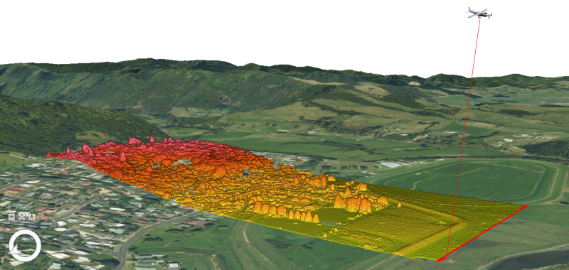
Light detection and ranging, or LiDAR, is a technology that uses airborne lasor sensors to rapidly collect point measurements of land from which digital 3D model replicas can be produced with point-accurate elevation surfaces.
This aerial method allows the collection of information for land within dense vegetation or steep slopes that can’t be accessed by surveyors.
The data enables the production of 3D elevation models of
- bare earth (Digital Elevation Model (DEM))
- surface structure, such as buildings and tree canopy (Digital Surface Model (DSM))
- colour-coded land surfaces like waterbodies, roads, vegetation (Point cloud)
- colour-coded elevation classes (Point Cloud)

To ask for help or report a problem, contact us
Tell us how we can improve the information on this page. (optional)